5:10 On our way. There was a little fog in the channel but the water was glassy smooth as we headed out into the big Hecate Strait.
06:20 Passing the White Rocks lights at the north end of Banks Island. Now it's open water but there's three or four mile visibility and only a one foot chop as we point our nose toward Cumshaw Inlet 55 miles away to the southwest.
08:15 We pass though a big school (Pod?) of leaping dolphins. They seemed to be jumping out of the water all around us but didn't come around to play. One kept leaping for six or eight times, kind of like the sailfish we used to see down south.
12:30 The Cumshaw entrance. Fog lifting now and the mountains of Moresby and Louise Islands are visible with blue sky behind. Cumshaw is a long inlet and we've still got an hour of running. Chuck's out taking pictures and the ladies are sunning on the deck.
|
|
13:50 We make a pass past Beattie Anchorage where Lois and I stayed in '87. The public buoys are still there but now there's also an active logging operation with trucks dumping logs and little tugs running around moving booms. The Pilot says there's also a buoy in Gordon Cove about three miles farther in so we decide to take a look there. |
After a lazy breakfast we all piled in Stormy and headed for shore. It wasn't an easy landing. We were at low tide and it was hard to find a spot where we could get off close to the logging road. We managed though; and, after climbing up over slippery rocks and fighting our way through a few hundred yards of forest, we emerged on the road. From there on it was easy, a nice walk along a gravel road through the forest and over the hill to the log dump above our anchorage and then Moresby Camp. Lots of deer and raccoon tracks and even a little bear scat. Along the road are piles of cedar shake blocks being salvaged from the downed cedar in the forest by some enterprising young fellows. We met one of them driving a truck loaded with the blocks. They are stacking them out at the landing where they will be loaded on a barge and taken to the mainland for sale. He told us that one of the pallets, which contain about 1 ½ cords, sells for $700 and will make about 10 squares of shakes. It's beautiful cedar, and all cut from trees lying on the forest floor. The leader of the crew, a young Finn who I met later, told me that in the forties, when they were harvesting spruce for the Mosquito bombers of the war, there was no market for red cedar so the loggers just cut anything in their way and left it lying there. Near the camp, which is abandoned now, we came upon a mother deer and her pair of spotted fawns. Pretty little buggers, neither they nor their mother seemed to be very worried about us. She just herded them slowly off the road as we approached.
I had anchored Stormy off the shore to keep it from ending up on the barnacle covered rocks as the tide came in, and when we got back and I tried to pull up the little folding anchor I found it stuck tight to the bottom. I pulled every direction but couldn't get it loose so we had to leave it. I suspect it's snagged by an old logging cable. Hopefully, tomorrow's morning tide will be low enough to let us recover it. Spent the afternoon in the cove. The ladies sat in the sun on the upper deck. Chuck went fishing again and brought home a string of little rockfish. Later I ran over to Moresby Camp to see what the landing is like. It's sort of the jumping off place for all of the southern islands. Several cars and trucks are parked there. Talking to the shake block guys I learned that the boat we saw yesterday is a personnel transporter for Selwyn Camp on the other side of Louise Narrows. They said it's a big operating camp with a bowling alley, golf driving range, tennis courts, etc. A RCMP van also came driving up while I was on the float. They were looking for a missing boat that had supposedly been here this morning. I hadn't seen it but Chuck said that a boat of that description went roaring out while he was fishing.
Ate a bunch of our crab for dinner but still have a lot left. Tomorrow we'll try to catch a salmon or halibut.
10:00 Dropped the mooring line and we're off to do some fishing. We dropped in the lines just outside the entrance to the cove and fished our way across Gillatt Arm. We were almost to the mouth of the arm before we got any action but then Chuck pulled in a beautiful five pound Coho. In just minutes he had another on but it made a big leap into the air and threw the hook. I'd been below and when I came up I noticed that my line was looking funny. Something had hit hard and broken the 30 pound leader taking my lure and flasher with it. That was it for salmon. We fished for another hour with no more action so we decided to go find a halibut.
13:30 At the mouth of Cumshwa, high on the rocks of the south shore, there's a sportfishing boat. Must be the missing boat of yesterday. Today there's a big trawler standing off shore, evidently waiting for high tide to pull it off. The bottom shoals slowly at that point. It should have been easy to anchor off if there'd been an engine failure. The boat must have been intentionally grounded. Wish we knew the story.
14:00 Fishing on some humps off Skedans bay. Not a bump on either of our hooks. I was using a jig and Chuck a baited hook. Nothing. Well, back to salmon fishing.
15:00 Bam! A fish on each of our lines. At first we thought we were tangled but then each of us pulled in a nice big "Black Sea Bass". We don't complain about that. They will each make a meal for the four of us.
16:30 Fishing again in the mouth of Selwyn Inlet. There's a small boat here anchored and fishing a very small 17 fathom hump but it hauls up and leaves as we troll by. We have no luck trolling so run on into Thurston Harbor.
17:15 Tied to a buoy in Thurston Harbor, another very pretty, well protected anchorage with four Fisheries and Oceans mooring buoys surrounded by high mountains. I baked Chuck's Coho for dinner. Boy, was it ever good! We're eating well but catching more than we're eating.
| Along the road the Salmon berries are bearing but all the berries have been harvested, and a fresh pile of bear scat showed where many of them had gone. We didn't see the bear but there were several deer grazing in the flat at the head of the bay and many raccoons foraging at the tide line. There are lots of Oyster Catchers here. Flights of ten or fifteen of the red beaked and footed birds go whistling by every few minutes, and they seem to be on every beach at low tide. | 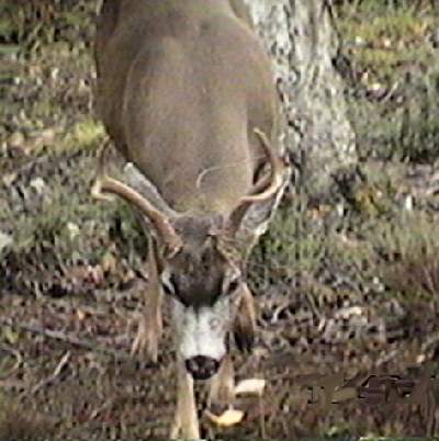
|
09:30 Cast off our buoy and headed out. Low slack was predicted for 11:10 this morning and we thought we'd try to anchor on a hump in the inlet and try for halibut again.
10:00 Found our hump alright, at N52o51.00' W131o40.35'. It's uncanny how the GPS will lead you to a spot where there are no landmarks. We used a system different from usual to anchor. I was a little worried about dropping our big anchor and 100 feet of chain straight down to an unknown mountain on the bottom; so I dug out our little lunch hook and shackled it to our nylon rode. Worked great. We set a solid hook in what felt like a sand bottom and had over six hundred feet of light nylon rode to play our depth with. We started out fishing at 110 feet but got nothing but rock fish. Then the small boat we'd seen fishing here yesterday stopped by and we found that it was the young Finn I had talked to at Moresby. He said we ought to be fishing deeper if we wanted halibut. Okay, we dropped more rode and drifted back to a depth of 180 feet. Still no action from the 'buts.
12:30 The ladies have been sitting in the hazy sun on the deck cracking crab and they've made crab and cheese sandwiches they want to broil. Still no action on the lines - we had three out - so I decide we ought to haul in and cook the sandwiches while we're running. Then my reel starts to sing. Fish on! Pulled in a beautiful ... that's stretching it a bit ... twelve pound 'but. It and the rock fish will make about six more meals for the four of us.
14:00 No more action from halibut and it's starting to rain so we decide to give up. But now one line is stuck to the bottom. Hauling anchor took teamwork. Chuck tended the stuck fishing line; Lois tailed, and Bernie stowed, the anchor rode while I ran the windless. It takes quite a while to haul in 600 feet of line but when we finally got it all on board I was able to maneuver to get the fishing line free. We're on our way again.
|
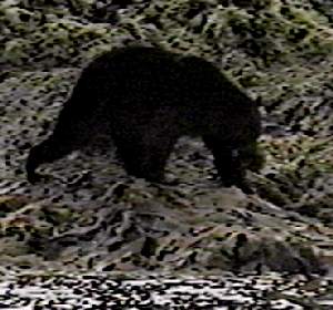
16:00 Anchored just outside the rapids in Lagoon Inlet, another very pretty and isolated spot. Deer on the point beside the boat and in the flat across the lagoon; eagles all around, including one that swooped down right behind the boat to pick up a little rock fish that Chuck had dumped out; and a big black bear grazing on the flat. Chuck and I ran into the lagoon in Stormy hoping to get a better look at the bear but he moved off into the woods before we could get close. First bear we've seen this summer. According to the book, the Charlottes have the biggest Black bear in the world. |
Filleted our fish ... I remembered pretty well how to do a halibut ... and had baked halibut for dinner. It just can't get much better than this.
09:00 Anchor up at our very comfortable anchorage just as the lagoon rapids is really getting going. We were parked in an eddy and hardly moved all night, but there's a real white water river coming out of the lagoon. We ran across the inlet to take a better look at a wreck on the beach, then headed around the point and into Sewell Inlet. I'd gotten some checks ready to pay the monthly bills and hoped to find someone at the logging camp there who would post them for me.
11:00 Anchored off the floats at Sewell Camp. There were a couple of empty slips on the float and there seemed to be plenty of water but old SEA RAVEN is just too big to tie comfortably in a 30 foot slip. So we dropped the hook and took Stormy in. It's a short walk from the floats to the camp. It seemed very quiet for an active camp. All the trucks were parked along the side of the road and the sound of a grader working on the road was all we could hear. Finally, at a big shed that looked like the truck maintenance center we spotted a guy in a pickup and I asked him about taking my mail. "Just drop it at the post office on the other side of the bridge.", he said. Sure enough, after walking a couple of hundred yards and navigating a bridge just being built with logs two feet in diameter, we found an office of Canada Post. We were met by the driver of the grader who also turned out to be the camp caretaker. His name is Jack Collier and he explained that the camp is on an 8/28 schedule, work 28 days then 8 off, and this was the shutdown period. The crew was all off in town. Nice guy. Took our mail; showed us their pub, a good sized building with bar and lots of pictures of old time logging on the walls; and, when I asked about buying some gas for the outboard, said he couldn't sell it but insisted on giving us 5 gallons. He recently lost his son in a freak incident. Traveling in Africa with a tour, the son was hit in the leg by a poison arrow and killed.
12:30 On our way again. As we were leaving Jack had mentioned that South Moresby Lodge in Pacofi Bay was a pretty nice place; and, since this was our day for socializing, we decided to stop there. It is only a few miles away.
14:00 Anchored at the head of Pacofi. Big lodge here, and busy. Small boats running in and out. We piled in Stormy again and headed for their float house. There we were welcomed by John, one of the guides, who invited us up to the lodge to look around and have a cup of coffee. It is a very nice setup. The lodge, a big Lyndall Cedar buiding, is only two years old but already they are 90 percent occupied for the season. They take their guests fishing both on this side and also on the west side by driving them over logging roads to Tasu Sound. Right now they have a group of 15 guests from Empire Foods in Oregon and Washington. There's a gift shop in the lodge ... Lois bought a shirt and Bernie some post cards. In the kitchen the cook, a guy who obviously enjoyed his own cooking, was pulling some beautiful pies out of the oven. We asked about coming in for dinner, but they aren't set up for transients and it didn't seem like that would be popular with the guests so we dropped that idea. When we got back to the dock we found a big frozen salmon in Stormy. John said he had caught it and had more than he could use. He also gave us a package of frozen herring.
17:00 Cranked up again, this time to go in to the float and fill our water tank. Spooky! We had been warned at the lodge about the reefs in the bay. The Pilot says there is a 450 foot wide channel with a minimum depth of 27 feet, but there are no markers and it wasn't easy to find. For future reference it is 0.06 NM off the south shore for 0.20 NM from the float house. Head from center bay to a small point on the shore at that distance. Once we got there a pretty young lady named Allison helped us tie up and fill our tank. We gave her and her coworker, Jason, a tour of the boat.
18:00 Tank filled and running again. Decided to go to another nearby anchorage, Cecil Cove, for the night. There we saw the biggest black bear yet, a real monster grazing in the flat at the head of the cove. And also a moose, the first we've ever seen from the boat, and her calf. (Is that what you call a baby moose?) Rocky bottom in Cecil though; we rumbled all night long.
09:30 Pulled a surprisingly muddy anchor from the rocky bottom. It was well stuck in spite of all the grumbling. Ran out of Cecil, across Selwyn Inlet and down through Dana Passage into Dana Inlet. Now we're on the south side of Talunkwan Island only a couple of miles from where we were fishing day before yesterday.
10:20 Passing Helmet Island at the mouth of Dana Inlet a couple paddling an outrigger canoe crosses our bow and a big inflatable carrying six kayaks and a load of passengers goes scooting by headed for somewhere in a hurry. Those are the first tourist types we've seen other than for the men at South Moresby Lodge.
11:00 Stopped and fished for a while on the north side of Kunga Island where we saw a couple of the lodge boats fishing. Didn't get a bite and didn't see any action from the lodge boats either.
| 12:00 Anchored off the south beach at Tanu. Had lunch then went ashore to see the old village. Very much as I remembered it from 1987. The remains of about twenty-five log houses of the Eagle clan. No recognizable totem carvings and most of the corner posts have rotted away dropping the roof beams to the ground, but there's plenty of evidence of the sophisticated building techniques of the people who lived there. At the Haida Guaii watchman's cabin we found Zeke, a man of about forty who told us he was a fisherman and logger on a paid vacation and didn't know a lot about the history of the place. He did have quite a pile of reference books though, one with a description and pictures of Tanu in the 1800's. It was home for over 500 people then. It's in an ideal location with a fresh water stream and rock protected coves both to the north and south which would provide easy landing sites for dugout canoes. Zeke had just finished butchering a 100 pound halibut which he'd caught not far from where we were fishing this morning and as we left he insisted on giving us a package of beautiful steaks. We've got so much fish we don't know what to do with it. | 
|
14:00 On our way again. Chuck still not really ready to stop fishing but weather turning sour ... wind out of the south and raining ... so we head for home while he takes a nap. I promised that I'd wake him if I saw any real sign of fish on the sounder.
15:30 Dropped hook in Echo Harbour, a pretty little landlocked cove where we stopped for lunch on a sunny day back in '87. No sun this afternoon though, we spent it on the boat watching the rain pour down. Had the last of our crab for dinner. It takes up too much room in the freezer.
| While pumping the rain out of Stormy this morning, I decided to take the easy route and drain it by pulling the drain plug and running. In doing so I discovered a delightfully pretty little lagoon just beyond a high walled passage at its head. Deer grazing on the flat ... they seem to be everywhere ... eagles in the trees above, two big Blue Herrons getting breakfast on the shore, and a white water falls pouring into the far end of the pond. After breakfast we all went back for a look and to let Chuck take pictures. | 
|
09:45 On our way. Much nicer weather this morning. A few streaks of blue in the sky, no wind and water flat as the proverbial mill pond. Ran out of the cove and southeast down Darwin Sound without a ripple on the water.
|
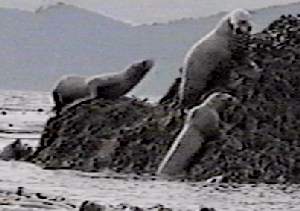
10:20 I counted nineteen seals basking on the rocks at the north end of Shuttle Island and on the rocks at the other end another big bunch dove off into the water before we could get a count. They seem to be everywhere. Must be feed in here for them but I'm not seeing any sign of big fish on the sounder. |
12:30 Fished our way past Ramsey Island with nothing but a couple of small rockfish, then again off Werner Bay with no success.
14:30 Stopped at All Alone Stone, a pinnacle rock in Juan Perez Sound which rises from the 300 foot deep bottom. No success here either although I hooked some poor fish in the eye with my jig. When I reeled in nothing came up but the eyeball.
16:00 Anchored in a little unnamed spot to the west of Dolomite Point, tiny islands and rocks all around. A deer watched us as we dropped anchor and settled down for the evening. Sun out now although it sprinkled a little earlier. There was a good sized sailboat anchored in the Dolomite narrows as we came in, presumably they were checking out the narrows while waiting for high tide. I made a map of the narrows and ranges when we were here before but I'm not sure I have the guts to use it. We'll check it out tomorrow. Had the halibut Zeke gave us for dinner. Are we ever eating good!
09:50 Going again. Decided to go around Burnaby Island and try to get to the south side of the narrows at low tide. Back up the strait and through Section Cove headed east. Poked our way through a couple of shallow spots on north Burnaby and then past Saw Reef out into Juan Perez Sound and the big Hecate Strait. The north winds they're predicting haven't materialized yet. It's calm out here, and what's more the sun is shining.
11:50 Stopped to fish on a six fathom bank out in the middle of 40 fathom water. I had barely bumped the bottom when I got one, a five pound copper colored rockfish. We fished for an hour while drifting from 60 feet to 300 feet in depth but couldn't scare up another. It stared to rain where we were so we moved out to Joyce Rocks where we fished for another hour while the ladies sat in the sunshine. Caught more rockfish but no halibut or Ling. Oh well, it's dinner.
14:00 Still raining heavily over toward the narrows so we decided to skip the clam dig and head for Rose Harbour. Down the big Hecate in bright sunshine and no wind. Bernie, Lois and Chuck sitting on the deck as we cruise down the side of South Moresby past Ikeda Cove and Carpenter Bay. Quite a few commercial fishing boats heading north in the strait. Must be an opening somewhere.
16:30 Tied to a buoy in Rose Harbour, the sun following us in. More homes here than I'd remembered. Three in the cove near the mooring buoys and another very nice looking place a little farther to the west. We sat on the deck and watched a man and his eleven year old son teaching themselves how to windsurf. They did pretty well considering that they'd had no instruction. The guy stopped by and talked for a few minutes. Said the sailboard was borrowed from a friend. By eight o'clock the sky had completely cleared. Looks like tomorrow might even be better than today.
Sometime during the night a nice looking sailboat from Vancouver snuck in and moored to one of the other buoys. It's the OCEAN LIGHT, a sloop with more rigging than any other I've seen.
08:10 HRO off, and we cast off leaving the OCEAN LIGHT still moored. As we exit the Houston Stewart Channel there's a lone kayak with two paddlers coming from somewhere outside. It's pretty bouncy out there this morning. Wonder where they came from.
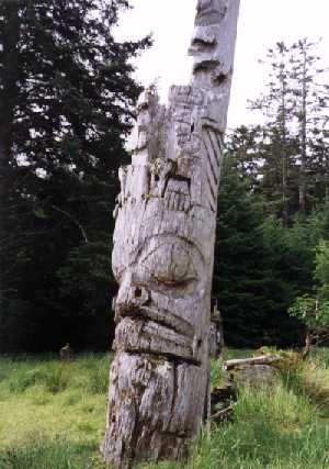
09:40 Anchored off Anthony Island after a couple of miles of splashing into the waves. Nice and quiet here behind the island. We're at high time this trip and it's an easy landing for the ding in the gravel beach pool in front of the old village where the totems stand.
|
As we poked around the ruins the Haida Guaii watchman appeared and welcomed us to the island. A nice guy named something that sounded like Wanicum, he was much more pleasent than the guy who threated to run me off back in '87. He registered us, gave us Haida Guaii "Passports", and told us a bit about the village. No charge this time. Either the Haidas have changed their policy or we were ripped off before. |
| The totems, houses, and mortuary poles are still beautiful in spite of another seven years of decay. The carvers who did them were masters of the art. One other group came in while we were there, a guided party in a big Zodiak all dressed in foul weather gear. Sounded like they had a wet ride across. | 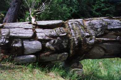
|
11:10 Anchor up again. Easy run up Louscoone Inlet to a pretty little pocket just north of Etches Point where there's another Fisheries and Oceans buoy to tie to.
12:00 Moored, had lunch, and settled down for a working afternoon. I pulled the watermaker filter ... in very good shape after only a few hours of running so I just washed them down and put them back. Lois did a load of wash; Chuck and Bernie went to the beach to dig clams. Over on the beach of a small island north of the moorage there were five double kayaks pulled up inder the trees and we could see tents behind but only one guy sort of poking around the beach. Seemed like pretty late for kayakers to be sleeping and the island's too small to take much of a hike. Mystery solved a while later when a big twin engine float plane came in and unloaded seven passengers. This is a base camp for kayak tours. The float plane did something I'd never seen before - he swung around until he had his tail to the beach then he reversed the props and backed up onto it so his passengers could step off. About an hour later he brought in another load of passengers. After an hour or so of instruction and gearing up most of the kayakers took off out the entrance. We never saw them again.
Today was Chuck and Bernie's wedding anniversary so we celebrated with london broil for dinner. First time in a long time we've had something other than seafood.
06:30 Passage north of Anthony Island. If the wind had been blowing like it was yesterday we'd have continued south and gone back through Houston Stewart; but this morning there was no wind and just a little lumpy swell coming through the reefs so we turned west into the big ocean. No sweat in the passage; had a minimum of 40 feet all the way through. As we got into deep water on the other side the lumps smoothed out into low swells coming from several directions.
07:00 HRO on.
09:30 HRO off as we pass Gowdas Rocks at the entrance to Gowgaia Bay after a very easy passage. Never had to think about putting the flopper stopper foils in the water. Easy entrance to the big bay even without a detailed chart.
09:50 Anchored near another small cruising boat called the ANVIL COVE in the northwest corner of Goski Bay. Anvil Cove is the name of a cove in Flamingo Inlet which we passed on the way up. Maybe our neighbor is a local.
Yep, turns out that the boat, a sturdy steel motorsailor, was built by the skipper and is here chartered to the province for an archaeology survey. There is one professional archaeologist and four young Haidas who are helping him look for traces of former living sites. Chuck and I talked to the cook, Mary Jane, who was tending the boat while the skipper and his five archiologists were off doing their thing.
| Spent the rest of the day beachcombing. This is a paradise for that. Chuck even managed to find one of the Japanese glass floats. But Lois outdid him for quantity brought back: two hardhats, dozens of plastic floats, net, a box, and lots of other "good stuff". | 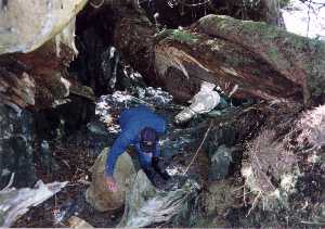
|
On our second expedition, the ladies and I ran across a huge sea lion who seemed to be ill. He, or she, was almost cream in color and was lying on the rocks, very reluctant to move. It slid into the water when we got too close but was back on the rocks when we returned an hour later. It was all alone and acted unlike any sea lion I've ever seen. Sad.
07:00 An hour and a half and we've still got five to go. Not worth the effort when they are predicting better weather tomorrow. So 180o and now we're riding down the waves doing almost nine knots with the f/s out.
08:00 Back in Gowgaia. This time we opt to look at other parts of the big bay. It's about four miles deep with one arm that reaches far around the corner to the south. We poked along the shoreline through Soulby cove, the anchorage the Pilot recommends ... it has an interesting looking beach but is open to the north, and on to the far arm.
08:45 Anchored at the head of Yakulanas Bay. Put down Stormy and went ashore. Another neat beachcombing place. Not as much trash here as where we were yesterday but Chuck managed to find another glass float, a small one which, much to Lois' delight, he gave to her. The archaeologists were surveying just down the beach from where we were anchored.
We spent a couple of hours there and then, when the wind started to pick up, hauled up and moved back to the north anchorage.
12:30 Anchored again, a little closer to the beach this time and we hit sand with our hook rather than rock. Had lunch then Chuck and I set off for more beachcommbing while the ladies stayed on the boat reading. No more real treasures but we had a fun afternoon anyway.
10:00 Into the entrance at Tasu right on schedule. It's a narrow slot in the high granite cliffs but inside the sound opens up into a huge multiarmed bay. We stopped to fish as we came though the opening but the wind, which had been almost calm outside, soon stopped our efforts when thirty knot gusts made steering at idle speed impossible.
11:00 Made a swing through Hungry Harbor behind Gowing Island where the abandoned mining town is located then went on over to the place that looked like a good anchorage to me on the chart, Two Mountain Bay. When we got there it didn't look so good. It's a nice, landlocked little bay but they've recently logged all around it and it seemed to have nothing but rocky shores.
| 12:30 Back in Hungry Harbor and moored to a huge ship mooring buoy. I just stepped off onto the top of the buoy to tie our line. We spent an interesting afternoon exploring the town and mine facilities. There are several very nice homes which look like their residents had just packed their clothes and walked out. There are TV's, refrigerators, toasters, cleaning materials, etc still there. Some sick minded visitors have broken windows, smashed the TV's, and dumped trash over the beautiful carpeting, but it is obvious that these were very nice, well kept homes before they were abandoned. Rhododendrons are just now in full bloom here and there were many of them around the houses. It was like any modern residential community. They had power, water, street lights and even normal telephone service. We found the communications station where a microwave antenna link with a high mountaintop probably made a relay link to the mainland. | 
|
At the mining facilities, a mile away from the residential area, most of the machinery has been removed but the concrete foundations and wharf bulkheads remain. We found a listing of all the equipment which was delivered on a ship in 1966. Newspapers around seemed to indicate that the last people left in 1991. According to the literature there were more than 500 people here at one time. The mine, we think it was copper, covers the side of the mountain above our harbor and huge piles of tailings slide down into the bay. It was a big operation.
We had oven baked salmon again for dinner and, just as I pulled it out, Gennie's alarm went off. Impeller? I'll check in the morning.
06:50 Cast off our big ship buoy and running after a quiet night in Hunger. Raining this morning so I let the ladies sleep in a little longer while I checked out Gennie's problem. Figured winds wouldn't be building as early.
07:30 Out the entrance and into the big waters. Still pretty lumpy out here but no wind, and the swells from the west seem to be longer, but there's some nasty short stuff coming out of the south now that gives us a kick now and then. Nothing to stop us from running though. We've got a go.
10:00 Off Englefield Bay now but five miles out. I can't seem to hold a heading greater than 280 degrees. Englefield was our number one destination but with the rain and poor visibility, and with the weather man saying that there's a front coming through tonight, we decided to skip it and go on to Skidegate 12 miles farther north.
11:30 Dall's porpoise, ten or twelve of them, join us and stay for a long time, almost to the Skidegate entrance. I was having trouble holding a heading for the entrance and had to tack once but the porpoises stayed with us. First time this summer a big group of them has stuck with us. Lois says that's a good sign.
12:30 Around the offshore rocks at Tcenakun point and into Skidegate channel, happy to put the swell behind us. Several fishing boats trolling in the channel as we pass. Tomorrow we'll try to follow one of them on the trip through the narrows.
13:40 Tied to a public mooring buoy in Amentieres Channel. The wind had picked up just as we entered Skidegate and it's blowing and raining here. Looks like we got in just in time. Settled down for a restful afternoon in the rain. I spent a good part of it studying the chart for the narrows. Spooky! Lots of places where we'll only have a foot or so of water under our keel. Oh well, that's tomorrow's problem. The storm really hit about the time we went to bed, strong wind and rain coming down in sheets. Glad we're safe and sound in here and not outside.
10:55 We've got 56 feet now so we cast off the mooring and run slowly for the West Narrows entrance by Downie Island. I had waypoints set in the GPS, and all our landmarks firm in my mind as we approached. Started out real good. We passed hit the first narrow channel on the nose, passed between the drying rocks on the right and the shore on the left, found the marker on the shore where it ought to be, and started the slow turn to the right to pass between two more shallow areas. That was when a big jet boat came roaring through from the other direction. He slowed down as he passed us but suddenly both of our sounders quit working; the bubbles of his wake had wiped out the bottom for both of them. I steered just a little bit to starboard trying to pick up the bottom and guess what, I did, with our keel. Rumble, rumble as we slid across the gravel bottom. The current was pushing us along and the scratching only lasted a few seconds before I was able to steer back into the channel but it was spooky. We all breathed a sigh of relief when we reached the deep water of Trounce Inlet.
11:30 After that experience I figured I'd like a little more water before heading into East Narrows so we took a slow tour of Trounce Inlet. It's about three miles long and a half mile wide ending in a wide flat at the head. Pretty setting, with high mountains all around, most of which have been logged fairly recently. Still some logging activity in one spot.
12:40 Ought to be about 2/3 the way to high tide now so we head into the second terror. Now the tidal flow, instead of being with us, is against us so I had to use quite a bit of power to maintain steerage in the channel. At McLellan Point it was really fast ... the pilot says it can be up to seven knots ... and I was whipping the wheel back and forth to keep up with the swirling water but managed to stay in the channel as planned. Then we started picking up the ranges: two markers, one above the other, red with a black stripe up the middle. The object is to keep them lined up as you approach or depart. Fortunately, all of the ones in the East channel face west so we could see them out the front window rather than having to have somebody shouting steering orders from aft. Chuck had the field glasses and coached me as we approached each set of markers. I had my hands full just fighting the current which kept setting us off to one side or another. In some ways the current helped; the deepest water is usually where the current is strongest. After passing through the last range markers there was still a tricky passage near the shore with nothing but a single marker as a guide. Now a fishing boat coming the other way was a big help to us. As we steered down the last range path we watched as he made his way close to the shore ahead of us, turning finally to pick up the range we were just leaving. That made it easy. We cleared the last hurdle and slipped into deep water without a hitch.
13:20 Terrors passed, we're heading for the big city. It's about an hour run from the narrows to Queen Charlotte City in Bearskin Bay. The clouds broke up, the sun came out, and the crew sat on the deck enjoying the sunshine. Nice day.
| 15:00 Tied to the dock in QC City. First time in civilization for two weeks. Dumped our garbage, we had quite a collection; walked to the post office to send some mail; picked up a few groceries at the store; and checked in with the folks at home on the phone. We have power on the dock here but no water. We'll have to go to the loading dock to fill our tank. Chuck and Bernie took us out to dinner at the Sea Raven Motel and Restaurant and I exchanged cards with Ron MacDermott, the manager there. He said they'd been using the name since 1961. | 
|