Well, the day finally came. Our plan was to catch the 08:05 but, as usual when we're going somewhere, we were all ready at a quarter after five. No point in just sitting around waiting, so we ran on down and got aboard the 06:00 which wasn't full this Friday morning. Got to Anacortes about 07:30, long before the drivers license office was open, so on we went to Mount Vernon. There was a little excitement there this morning...some kook with no clothes on was on top of a semi on the freeway demanding a Bible. He had the freeway closed down with all the traffic detouring through downtown Mount Vernon. We never saw him, but we sure saw the effects of his actions. News helicopters and airplanes were buzzing overhead and traffic was backed up for miles. By bucking the direction of flow we were able to avoid most of it and make it to the licensing office about ten minutes before they opened. Lois was their first customer.
We stopped at Fred Meyer's for film and video tape but still got to the Bellingham Ferry Terminal before ten where the Alaska Marine Highway ticket agent re-issued all of our tickets to fit the correct itinerary. Then we had three hours to kill. They don't start check-in until 12:30. Chuck had told us that we ought to check in early so we could relax and watch the loading process. Ha! We were one of the first to check in, and close to the last to go on board.
| They didn't start loading any cars until after four and, when they did start, they seemed to load one at a time with several minute in between. Fortunately, it was a lovely day, we were at the front of lane 1 where we could see everything going on...damned little, and the temperature was a perfect 78 degrees. It was 7:30, an hour and a half after we were scheduled to sail, before they called us. The thing that did it was that Lois, who had been holding it for hours, decided that she had to go to the bathroom. Yep, once she was out of sight in the terminal, they motioned for me to drive on. Well, she came running back as the Purser was taking our tickets and on board we went. |
|
Car deck operations, unlike those on Washington state ferries, seemed chaotic. There was no one to guide us or, more importantly, to tell us where to go once we were parked. I had my pack on my back and a bag in each hand, Lois had her big bag plus two more, and the cars were packed so tight we could hardly move between them. I spotted an elevator gate just a car away and headed toward it. Lois and I got in, then two other people with all of their baggage tried to crowd in behind us even though there was obviously not enough room. By this time I was losing my cool. I pulled the gate shut, leaving the guy outside, and pushed the Cabin Deck button. The elevator went up and stopped but the gate wouldn't open. So, down we went to the car deck again. This time the gal got off and there were two ferry employees there who told us that this elevator only went to the galley, that we'd have to go all the way forward on the car deck to get to the passenger elevator. "No way!", I said, slammed the gate closed again, and pushed the Galley button. That's where we arrived, much to the concern of the galley crew who pointed us in the direction of the passenger elevator, but at least we didn't have to fight our way forward on the car deck.
Things started to go better once we found our room. We have room 114 on the "Upper" deck. Right next to the purser's office, it's pretty nice with a big shower, four wide bunks...we only used one, and a window looking over the deck outside. We got settled then had a drink and went to dinner in the dining room where a waiter named Dennis served us a glass of wine and a BIG Caesar Salad. Tomorrow we'll check out the boat.
Saturday, June 14, 1997
A long and boring day on board the COLUMBIA. I got up about 04:30 and went to the Snack Bar for coffee. We were somewhere in Johnstone Channel, although the Purser's red "You are here." pointer was still on Powell River. That had me going for a while, but we've been this way too many times in SEA RAVEN for me not to recognize the area. The weather was nice most of the day and the ferry has a big forward seating area where we could sit and watch the scenery go by. The seas in Queen Charlotte and Milbank Sounds were almost flat so we seldom had any movement of the boat. Had breakfast in the dining room and sandwiches from the snack bar for lunch and dinner. Tomorrow we'll make our first landing in Ketchikan at six in the morning. Maybe from then on there'll be a little more action.
Sunday, June 15, 1997
Yes, today went a little better even though I wasn't feeling very good. We spent most of the day up in the observation lounge watching the world go by as the rain poured down. We got into Ketchikan at 06:00 and were there for two hours. Then it was on to Wrangell in the rain. Got there about 14:00 and left at 15:30. The ride through the Wrangell narrows was interesting. Dozens of eagles in the trees watching the human fishermen who were very reluctant to leave their fishing even long enough to let the ferry go by. Got to Petersburg about 17:00 but didn't stay long. The purser said that, due to tidal times in Peril Strait, they had to leave by 18:30. Lois and I ate dinner in the dining room while they were loading. We split a very good clam linguini for $9.00. Can't beat that for price.
Monday, June 16, 1997
A lot nicer day today both because I was feeling better, and the weather was much nicer. Waking to sunshine as we came into Sitka at 4:30 in the morning got the day off to a good start, and it just got better from there. We never saw Sitka. The ferry landing is about three miles north of the city and around a point, so all we saw of the famous old Russian city this time were the tour buses. Not a problem...the scenery around Sitka on a sunny day is spectacular. We were surrounded by magnificent Sitka spruce and snow streaked mountains on all sides. We left the Sitka landing at about seven and headed north through narrow passages to the entrance of Peril Strait. Lots of bald eagles and a few deer along the shores, and a Sea Otter that didn't want to move right in front of the ship. In Peril Strait I think I identified the cove where Lois hooked her big halibut in 1993, but I couldn't be sure. The charts we have with us don't give enough detail to correlate with my log. All the way through Peril they kept a crewman on anchor watch. I'd never seen, or noticed, that before, but through every narrow passage he's standing out there on the bow ready to drop the hook in an emergency. At the junction of Peril and Chattam Straits we saw our first humpback whale, and saw several more on the way up Chattam and back down to Auke Bay.
We got into Auke Bay at 15:30 and were there for 2 1/2 hours before heading on to Haynes. We had dinner in the dining room again, a seafood saut_ this time. Not as good as last night but very passable. We were in bed by seven thirty and slept on and off through the landing at Haynes and the trip to Skagway. At 01:00 the steward came pounding on our door giving us the "One hour to Skagway" warning. Off loading went easily. Most of the cars and RVs got off at Haynes. Once off the ferry we turned into a parking lot just outside, made up our bed in Henry, and hit the sack again. Didn't wake up until 05:30. Long night.
Woke to what felt like an earthquake and turned out to be the engines of the Nieuw Amsterdam being moored just across the parking lot. Four, count them, four huge cruise ships in here this morning: the Nieuw Amsterdam, the Sun Princess, the Crystal Symphony, and another that we couldn't see the name on. The whole town was getting ready for the tourist influx. The White Pass train was ready to go, dozens of tour buses stood at attention, and seven helicopters were warming up just across the road from us. It was a lovely, sunny morning, couldn't have been nicer for a tour. We got ourselves put together, had breakfast at the Old Prospector Cafe downtown, topped Henry's tanks at $1.699/gal, bought groceries, beer and booze at the liquor store, and called the Alaska Ferry terminal in Homer to change our itinerary, and headed out. Skagway is just a little too cutsie for us.
|
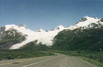
The drive over White Pass is as spectacular as we remembered it. The steep climb up the valley between towering, bare granite peaks makes you wonder how the pioneers did what they did. At the top of the pass, just across the Canadian border, the land flattens into a weird, pond dotted granite plain with only a few stunted trees as vegetation. It's here that Terry Williams told us they filmed the movie, "Never Cry Wolf". |
We'd driven as far as Carcross with Terry, but from there on the road was new to us. Today we poked our way along, admiring the bright displays of wild flowers along the roadway as our sunny skies gradually turned to gray. In White Horse we stopped for some MacDonald's chicken nuggets and kept on driving. Out of White Horse we stayed left toward Haines Junction on a road across rolling country covered with tall alpine spruce of some kind. (I screwed up and left my plants and trees book behind but found later that they are Black Spruce) Just east of Haines Junction at Pine Lake we found a nice BC campground and decided to stop for the day. Last night was pretty hectic and we were ready for a rest. Beautiful sunset at midnight, then the rain started and it rained the rest of the night.
What a neat day! It didn't start out all that great. Still raining when we got up and I wasn't feeling very good. I had a couple of coughing spells and the pressure on my chest seemed to weight me down. We had a breakfast of cold cereal before leaving camp then rolled on to Haines Junction where we turned left for Haines. The Haines road is advertised as a scenic highway and we figured that, since we'll never be as close again, we might as well see it. We weren't disappointed. A few miles down the road I decided that my "drug holiday" had lasted long enough and took a swig of my cough medicine. Wow! What a difference. In less than half an hour I was able to start really enjoying the ride. The Haines road winds along the eastern edge of the Saint Elias Mountain Range. The first half of it is in Canada's Kluane National Park of the Yukon. The second half is partly in British Columbia's Tatshenshini-Alser Wilderness area and partly in Alaska as it follows the Chilkat River to Haines. Out of the glacier scoured mountains of Saint Elias flow dozens of rivers and creeks fed by snow still lying in the huge vertical crevices which decorate every huge granite mound. No sharp peaks here, at least not visible from the road. All of these mountains have been nicely rounded by the glaciers of 12,000 years ago. The rivers in turn feed lakes which seem to be everywhere, and all of this almost completely uninhabited. It's not hard to guess why. The snow in the valley and under the trees still isn't completely gone down here along the highway. The winters must be hard. In one of the many small lakes which border the road a pair of Trumpeter Swans were doing the bottoms-up searching for food.
At Haines, we bought a few groceries and a sweatshirt and pants for Lois, filled the tanks with gas at $1.66 per gallon, then headed back up the road. It was even prettier going back. The rain had almost stopped and the sun was shining on many of the peaks and valleys. At the junction we stopped again for a bowl of split pea soup and a few more groceries, then head north on Highway 1. We passed one nice campground on Kluane Lake but it was early and the map showed three more on up the road. Kluane Lake is a big one! It must be fifty miles long and wider than Lake Coeur d'Alene in most places. It looks shallow and, fed by glacier rivers, has a turquoise tinge. Once the road leaves the lakeshore at Burwash Landing it gets sort of boring, mile after mile of almost flat muskeg with nothing but brush and scrubby trees lining the road. And, once out of the parks, we found that the "campgrounds" shown on the map are commercial joints designed for the 'hookup' RV's. About five o'clock we were getting pooped and decided to stop, campground or not. We lucked out and, after one false start, found as nice a place as we've ever stayed on the bank of the Donjek River about a hundred miles from the U.S. border at Beaver Creek. It was pouring rain when we stopped, so we didn't get a chance to walk around, but we're parked in the trees right on the bank with the muddy river flowing by and a great view of the long bridge across the river. Still, we're far enough away that we can hardly hear the highway traffic. Neat spot! Had pepper steak for dinner, little steaks we'd picked up at Haines Junction.
Another neat day. Had bacon and eggs for breakfast on the bank of the river, then packed up and moved out. It started raining again almost as soon as we got on the highway but the road is good and the traffic light so the only problem it gave us was visibility. According to the books the scenery along this road is special, but low hanging clouds kept us from seeing much of it. Just past Beaver Creek we crossed the U.S. border again and just beyond it is the Tetlin Game Sanctuary. We stopped at the Visitor's Center and picked up some brochures and looked at exhibits of game animal furs and area geography. The lady in charge also loaned us an audio tape which we played on the way to Tok. It gave a bunch of interesting poop on the area, including the fact that this part of the country was ice free during the last great ice age. Not long after that the rain eased off and we started to see the Tetlin River Valley and mountains in the distance to the south. Got our first glimpse of what we think might have been permafrost where the road crews had cut away the bank and exposed a layer of icy earth beneath the scrubby Black Spruce forest. We dropped the tape at the Visitor's Center in Tok, filled the tanks with gas, and rolled on up the highway toward Fairbanks. At Delta Junction, which the brochures say is buffalo country, we stopped again and had a buffalo burger at the local drive-in. That reminded me that I'm not very fond of buffalo meat.
Just past Big Delta the Alaska Pipeline parallels the highway bridge as both cross the Tanana River. Busloads of tourists were gawking at the big pipe as we passed. It is a big silver painted monster suspended high over the river. Rolling on toward Fairbanks the traffic got heavier and the roadside businesses more frequent. By the time we passed Eilson Air Force Base things were looking like any "second class" city in the U.S. (That's how the Cof C brochure describes the town.) Not bad as cities go, Fairbanks has expressways around it's perimeter, the Chena River running through it's heart, lots of parks, and a beautiful university campus on the hill just northwest of town. We drove up and down the streets getting a feel for the town layout and looking for a place to stay for the night. Ended up at the Tanana Valley Campground next to the fairgrounds. Nice, quiet little privately owned campground in the trees with clean bathrooms and showers and laundry facilities. We'll be able to get ourselves cleaned up for another few days on the road.
| Went to bed early again with the sun high in the sky. Woke at 11:30 to see the sun shining on the trees across the street. I took a picture of the sun lighted grove and stayed awake 'til midnight hoping to get another shot at that time. No luck. Clouds moved in and blocked the sun. It wouldn't have meant much anyway; Alaska is on Daylight Savings Time. Ain't that silly? According to the lady on the radio, sunset this evening is at 12:48 ADT and sunrise at 02:13. | 
|
Lois was up early with me this morning, doing the laundry. She got that done, we had breakfast in the campground, and then we set off on another neat Alaska tour day, but only after a frustrating hour or so of trying to find a place where I could make an e-mail connection. Tried Kinko's first. No luck there. The guy I talked to said maybe next year. Why didn't I try the Cafe Latte? Well the Cafe Latte had two computers for 'surfing the net' but no telephone jack available. Tried a computer store where the owner said he'd be glad to help, but all his lines were long distance blocked. At a hotel the desk clerk tried, but her phone was hard wired and I suspect the room phones were too. Ah well, the folks back home will just have to wait a while for a report.
For our tour today we decided to drive out to Circle on the Yukon River. With the exception of the 800 mile long Prudhoe Bay road, Circle is as far north as you can drive on Alaska highways. At just under 66 degrees north latitude, it's only about fifty miles south of the Arctic Circle. It's 156 miles from Fairbanks, 44 of which are paved, the rest very well graded gravel and clay. Starting at the old mining town of Fox, the paved section of Alaska Highway 6 climbs first to a local ski area which reminded me of Sis and Paul's local family ski resort of Kelly Canyon. Snow free now, it looks like it would be great for family skiing. After climbing over the ski run mountain, the road winds through river valleys and over spruce covered hills, gradually climbing through two barren passes where nothing but tundra covers the ground. It was a cloudy and misty day and Twelve Mile Summit at 3,200 feet was covered with cloud both coming and going. On the other hand, Eagle Summit, only a few feet higher at 3,700, was clear and it seemed like we could see all the way to the north pole. Many of the creek bottoms are filled with piles of rock and gravel left from mining operations, and we saw several places where people were camped panning for gold. You can almost hear the cry, "Thar's GOLD in them thar hills!" Remains of mining equipment are scattered around almost all of the creek beds.
As we dropped down from Eagle Summit toward the valley of the Yukon, we followed Birch Creek which seems to be a favorite fishing waterway. The forest service has improved several access sites and it appears like you could float it all the way to the Yukon. We stopped in Central, the only community between Fox and Circle, and had a lunch at the saloon, a very good Turkey Spaetzel and ham & cheese sandwich.
| Then, 30 miles beyond, the journey ended at Circle, an Indian village which, according to the book, was the largest town on the Yukon before the gold rush. It's not much now, an airstrip, a few dozen log cabins, a lodge and trading post, and a few fishing boats for charter. We bought some juice at the trading post, took a few pictures, and headed back. The weather had improved for the return trip and we spent more time poking around on side roads...there aren't many. | 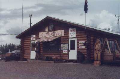
Circle Saloon |
|
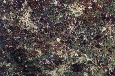
Up on the mountain we admired and took photos of the tundra flowers. They must be close to their prime. Tiny white, yellow, blue, purple, pink and red blossoms are everywhere. The tundra feels like muskeg to walk on. The mosses and low growing plants mass together to form a springy cushion under your feet. We need to go to a info center and read more about the stuff. |
About 16:00 we started looking for a spot to spend the night. Checked out several old mining sites accessible from the road, but ended up in the Forest Service's Cripple Creek campground about 60 miles from the start of the road. Really pretty spot in the trees overlooking the Upper Chatnika River. Only a few other campers here. We like the Forest Service campgrounds. With our "Golden Age" passport it only cost us $3.00 for the night.
Saturday, June 21, 1997
MOOSE!!!! Yep, not one, but four! A cow and three calves. But that's getting ahead of the story.
We rolled out of our Cripple Creek camping spot at six this morning with a horde of mosquitoes on our trail. Lois had insisted that we take a walk around the campground for exercise, probably a good idea but, by the time we'd been out five minutes both of us were covered with the tiny monsters. I must have gotten fifteen or twenty bites. We hurried back to the van, which fortunately we had all ready to go, jumped in and took off. It took a mile or so with the windows open to clear those that were still hanging on out. We've got to start anticipating and using repellent.
The drive back to Fairbanks this morning was interesting. We stopped once to argue with a young eagle who didn't want to leave its road kill. Whatever it was was too big to carry and it was sure reluctant to leave it to us. As we inched closer, though, it gave up and flew off into the trees. We stopped again at the University of Alaska Potlatch Flats sounding rocket launch site to take pictures of the sign and rocket at the entrance. In Fairbanks we had breakfast at the Sourdough Cafe, gave Henry a quick washdown with the high pressure hose at the carwash...he had so much mud on the rear windows that we couldn't see through them, then rolled south on Highway 6. The drive from Fairbanks to Denali is pretty and varied. Out of Fairbanks the highway climbs to the top of the hills between the Tanana and Chatanika rivers and follows a long ridge, giving many nice views of the wide valleys on either side. It drops down to the valley floor at Nanana where the Tanana and Nanana rivers join. We stopped at the general store there for a few groceries. From Nanana the highway follows the river up the gradually narrowing Nanana Valley toward high mountains in the distance-- the Alaska Range, home of Denali. Very pretty drive.
We started to get the feel of Denali National Park before we ever got near the entrance. Several miles down river we started passing lodges with lines of tour busses in their parking lots. Big signs advertised River Adventures, Helicopter Flights and Denali Information. The park entrance itself was low key enough, as are most national parks, but the parking lot at the visitor's center was packed as was the building. Our objective today was to make sure we had all the rules right and form a general impression of the place. We accomplished both in short order. The info I downloaded from the net is right up to date. There's a two day advance registration for campsites or bus tours, a boon to the lodge operators outside the park. From May until September you are not allowed to drive beyond the Savage River, 14 miles into the park. We drove that far, and stopped at the Savage River Campground to empty and refill our water tank. (The water we got on the way into Fairbanks the other day turned out to be dirty looking even though it tasted all right and didn't seem to cause us problems.)
From Denali we drove the 21 miles to the junction with the Denali Highway where we topped the gas tanks and had a cup of chili at the Chevron Station. Then we headed east. The books say that the Denali Highway used to be the only road to the park. You either took it or the train. It now runs from the George Parks Highway between Anchorage and Fairbanks to the Richardson Highway between Valdez and Fairbanks, a distance of about 135 miles. It's mostly gravel...not quite as well maintained as the one to Circle...but traverses some of the prettiest country we've ever seen as it winds across the Taiga and Tundra past hundreds of tiny lakes and streams. (That's an interesting thing we learned at the Park...the scrubby Black Spruce forest through which we've been traveling for the past several days is called Taiga from a Russian word meaning "little sticks". It's a very appropriate word for describing the appearance given by the stunted little trees.)
About 27 miles along the road, at the far edge of a little lake, I spotted our Moose. I had turned the driving over to Lois and was scanning the hillsides, not really expecting to see much but the long legged snowshoe hares which seem to be everywhere, when I saw this big shape off across the lake. I hollered, "Stop!" There she was with not just one, but three calves at her side. We were so overwhelmed that I didn't even think about the camera for a minute or two. When I did I realized that they were too far away for the normal lens. The 10 to 1 video lens would have done the job but I didn't think of it either. I got out of the van, opened the side door and started hunting for the zoom lens for the still camera. By this time though, Mama Moose had become aware of our presence and she wasn't too sure we were trustworthy...this is not a game sanctuary. She watched us for a while, gathered her brood around her, and then started moving off into the woods behind the lake. Ah well, photographer I'm not. I never seem to be quite ready when the right time comes along. Not long after that we spotted a trio of Trumpeter Swans in one of the tiny kettle lakes beside the road. I think I did get a picture of them doing the bottoms-up.
| At three o'clock I took over the driving again and started looking for a place to spend he night. It didn't take long. Just past a long bridge which wasn't marked but which I think might span the upper Susitna River, a road took off to the left back along the river. It looked sort of interesting and, sure enough, about five miles later we found a great parking place. High above the river valley we have a 270 degree view of the Alaska Range to the west and more mountains to the east with the wide valley floor laid out in front of us. Nice cool breeze and almost completely alone. Only three cars went past all evening. Great scenery, great day! | 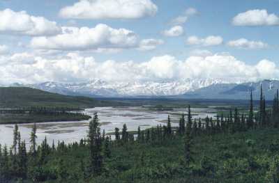
|
Sunday, June 22, 1997
And another one today, but with more sunshine and less rain. We woke to blue skies and sun shining on the mountains across the river. These glacial river valleys differ from those down south in that they are very wide with almost no vegetation close to the banks. The water at this time of year takes a meandering course down several shallow channels cut in the glacial sand, but during the spring thaw I suspect it fills the river bed and sweeps everything out of its way. We had breakfast on board...I fixed bacon and French toast...then decided to do a little further exploration of the road we were on and followed it for a few miles. It appears to lead to some kind of a mining operation, although we weren't able to determine what type of mining. It crosses a pretty creek, which we later learned is called Valdez Creek, and then climbs to an upper valley tucked between snowcapped mountains. The earth moving that has been done reminded us of a big housing development going in. My guess is that the land is being regroomed after mining operations, but we'll never know. One of the many little mysteries we run into in our travels.
|
Back on the Denali Highway we poked our way along enjoying the scenery and the pretty day. Saw more Trumpeter Swans...a sign along the road says that they love these kettle lakes formed by melting snow...and got some photos of a hen sitting on her nest. Farther along we saw several beaver houses built in the center of tiny ponds. No more moose, though. |
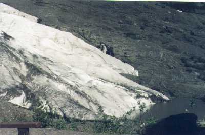
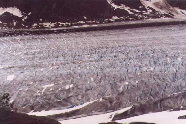
| As we approached the eastern end of the Alaska Range the mountains loomed larger until we came on McClaren Creek which flows from the face of the McClaren Glacier, I hope I got some good pictures of that big river of ice. Soon after that the gravel road turned into a bouncy, paved one as we approached the end of the Denali highway, and, off in the distance we could see the silver line of the Alaska Pipeline stretching across the hills. Sorry to have our remote road end, we headed south on the 65 mph Richardson highway. | 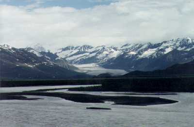
|
It was nearly four o'clock and the big gravel bar looked like a good place to park so we decided to stop and watch the fun. Nice evening. Our view is spectacular again. 14,000 foot Mount Wrangell is due north of us and 12,000 foot Mount Drum just to the west. Drum was in the clear but Wrangell was covered with huge towering cumulus clouds which gradually worked our way. We got only a few drops of rain, but had a great lightning and thunder show. We're liking Alaska.
Monday, June 23, 1997
|
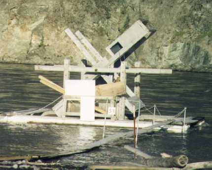
And it gets better and better. We woke to the sun coming over the mountains east of Mount Wrangell. Not a cloud in the sky this morning. The monster thunderheads which had hidden Wrangell last evening were all gone leaving it clear to see. That was a bit disappointing. Even at 14,163 feet Wrangell looks more like a low, snow covered hill than a mountain. It has none of the craggy features of the other mountains of the range. Mount Drum at 12,010 is much more impressive. We ate breakfast then drove farther out on the gravel bar to get a better look at the fish wheels, or "dip nets", the official name for them as we learned from a fisheries sign. |
| We got close enough to get good pictures and talked to a couple of guys who told us how they work. What we hadn't noticed before is the collector which diverts the fish to a holding basket as the scoop is on its downward cycle. Pretty slick! You have to have a special permit to use one. The guys we talked to said they'd arrived about midnight and hadn't done too well, only seven fish so far. Sounded pretty good to me! | 
|
|
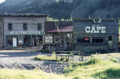
In town we stopped to take pictures of the Chitina Emporium and It'll Do Cafe; then, in a pool right next to the Chitina Saloon, we spotted a moose browsing. I got pictures this time although it wasn't easy. First off, when I walked back with my camera to get a good shot I found that I was out of film. Okay, back to the van, reload the camera, go back to take the picture, and find the film is jammed. Fumble, bumble. |
| Now the moose, only fifty feet away, moves out of the sun and into deep shadow but goes on browsing. Interesting how they do that. Standing shoulder deep they lower their head and neck into the water until nothing shows except their back. Anyway, I got my pictures and more. A half mile up the road we ran onto a cow with two calves then, a little later, an old, battle-scarred bull in another of the lakes that line the roadway. Back on Highway 4 south of Tonsina we ran across a young bull that ran down the paved road in front of us, slipping and sliding as he tried to decide which side of the road he wanted to dive off of. Loads of fun! | 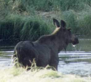
|
Tuesday, June 24, 1997
Wasted another couple of phone charges this morning trying to get e-mail, but finally gave up and went to old fashioned telephone and Snail Mail. We called Kris and Nan, and I printed out a trip progress report to send to the close family. Kris and Bob canceled out on meeting us in Homer. Bob gave us a story about not being able to get reservations, kinda kooky since he told me the other day that they'd be traveling standby. I suspect they got to thinking about the hassle and expense of the trip and decided to bail out. That's okay though, we were hoping that, if they came, they'd be able to come a week earlier. We decided to cancel our ferry trip out to Kodak. Hanging around until the 4th just to take another boring ferry ride was beginning to sound like a dumb idea. We're having too much fun land touring.
| Stuck around the motel most of the morning. Had breakfast in the dining room, wrote our letters, paid our bills, and got organized for more traveling. Then we went to the Post Office and the grocery store and headed out of town. We were long gone up Keystone canyon before I remembered we'd planned on hitting the museum this morning. Ah well, we've never really been into museums anyway. From the display in front of the building, I suspect it would have a lot about the big oil pipeline. Speaking of that, I also suspect that Valdez has the cleanest harbor in the world. One thing we might have learned in the museum is why Valdez is the largest, in area, city in Alaska. The city limit sign is ten miles out in the boons, beyond Keystone Canyon. Of Valdez' natural attractions, the Keystone Canyon tops my list. I'm not sure how it might have happened, but the river and highway squeeze through this narrow slot in a granite mountain only a hundred yards wide and several times as deep. Waterfalls and cascades are everywhere, Bridal Veil Falls being one of the prettiest. The canyon is only a couple of miles long but it must have taken some real engineering to put the highway through it. The remains of railroad tunnels can still be seen in several places. | 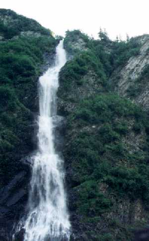
|
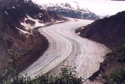
The eastern part of Highway 1 isn't very scenic, just mile after mile of taiga covered rolling hills. At about the half way point things start to get interesting as the highway approaches the mountains of the Matanuska Glacier. We had stopped for a highway construction crew and were poking along on a gravel section of road when we first spotted the glacier. At first it was just a strange white something far off down the valley. It looked like snow but was far too low in the valley to be that; on the other hand, it was far too white to be water. Not until we got to the point where we could look back into the valley from which it came did we realize exactly what we were seeing. Unlike most glaciers we've seen, the Matanuska doesn't flow down and out of a valley between mountains. That's the way it starts, but then it flows for miles along the side of a mountain, constrained in its path by a long ridge of glacier polished granite. There is very little debris carried in the ice so the result is a long, white line of ice along the base of the mountain above the wide valley floor. I wish I could have taken a picture, but it was still raining, the light was poor, and you'd need a panoramic lens to do it.
We found our home for the night at Alaska Park's King Mountain Campground. Nice, clean and uncrowded. So far we haven't had much trouble with too many people. We'll see how it is in the big city tomorrow.
Well, Anchorage is a big city all right. We rolled out of our campground about six and were in Palmer before seven. Picked up a MacDonald's breakfast sandwich there, then rolled on down the highway. Not far beyond Palmer we started picking up traffic and soon it was commute hour on the freeway, complete with the fender-bender which slowed traffic to a crawl for several miles. Not a big problem in the city at that early hour, though; we were able to cruise the streets without being totally terrorized. We found a phone book at Day's Inn and looked up the address of the one place in Alaska Kathy said was a "Must See", the Fly-By-Night Club. We found it all right, a grubby looking little bar on a back street in the southeast part of town. Hard to understand how my skiing, mountain climbing, outdoorsy niece would even stumble into a place like that, let alone have it become a "Must See". Of course, we saw it when bars are at their worst, in the early morning when the lights are off and the peeling paint shows and the outside appearance isn't what she recommended. It was the show inside. I think we'll skip that though, late night entertainment isn't our bag these days.
The drive from Anchorage to Seward is another pretty one. The Highway 1 South follows Cook and then Turnagain Inlets as far as the Whittier train depot at the head of Turnagain. There were several Princess tour buses and dozens of cars and RVs were lined up waiting for the train. We haven't checked it out, but the Wittier train ride looks to be another mass tourist attraction.
| From there the road climbs into the mountains, winding up beautiful green valleys and steep canyons to the junction with Highway 9 which leads to Seward. That's an exceptionally pretty drive. We seemed always to have beautiful lakes and meadows in the foreground and glacier mountains in the background of our view. Seward is also an exceptionally pretty little city for a major port. It too is surrounded by high mountains and gives the impression of being very clean and well kept. We stopped at Don's Cafe for a cup of soup, and at the thrift store where Lois bought a book and a pan. On the way out of town we bought some very good smoked red salmon at a nice looking place called the Smoke House. | 
|
The road leaves the Kenai about halfway across the peninsula and from there on the scenery is pretty mundane. Rolling hills covered with alder and many driveways leading off to private spots in the woods. As we approached Soldotna the signs of population grew greater until we could have been in any suburban town in the lower 48. Soldotna has all the franchises, from fast foods to quick lube joints. Henry was due for an oil change so we pulled into the Pennzoil 10 minute lube and spent an hour getting him serviced. Then we headed on north on what they call the Kenai Spur which, after going though another typical small. highway town, Kenai, terminates at Captain Cook State Park where we found a great campsite on a hill in the trees but with a nice view of the inlet. The Alaska Park Service does a great job with their campgrounds.
We sure can't complain about the weather we've been having the past few days. We came through a little fog on the way to the campground last evening and I was afraid that we might have some this morning here right on the water. Nope, just bright, warm sunshine. We rolled out of camp about seven after a breakfast of Shredded Wheat. Instead of following the main road back through Soldotna, we turned right at Kenai and took the bypass road that follows the shoreline and rejoins Highway 1 at Kosilof...lots of good Russian names in this area. More moose this morning, both in the ditch just off the side of the road. They look at first like horses as we drive by. The drive to Homer was another with eye popping scenery. The road runs right along the edge of cliffs over the inlet for a good part of the way giving a tremendous view of two volcano mountains on the far side, Mount Iliamna and Mount Redoubt. Both are active and the sign said that Redoubt erupted in 1989. This morning they were two big, white cones looming on the western horizon. Then, as the road nears Homer, it turns eastward and off across Kachemak Bay are the towering peaks and glaciers of the Kenai Range. We easily counted a dozen glaciers.
We arrived in Homer about ten o'clock and drove the length of the five mile long spit that forms the harbor breakwater. Here is where most of the economy of Homer is based. Logging trucks continually feed huge piles of logs on the waiting shipment, bulk cargo and container ships, cruise ships, and the Alaska ferry dock at the wharves, and a big, totally enclosed marina provides shelter for boats up to Coast Guard size. The real business however, at least at this time of year, is sport fishing. The whole length of the spit is lined with charter boat offices and associated businesses, gift shops, fishing supply stores, etc. A dozen or more RV parks contain hundreds of vehicles, and tents line the beach on the south side of the spit. It's Westport a dozen time over.
We took it all in, decided there wasn't a whole lot there of interest to us, stopped at one of the public facilities to fill our water tank, and went on with our sightseeing drive. Drove almost to the end of the "east end road" which runs up Kachemak Bay and provides some marvelous views of the Kenais, then back to town where we bought a few groceries and two books with much better maps of Alaska than that we've been using. Heading back up Highway 1 we were halted by what we thought at first was another road construction delay; but, after waiting about ten minutes and seeing an ambulance come by, figured out it was an accident. Fortunately, we'd just passed the junction with the "Old Sterling Highway" so we turned around, went back to it, and bypassed the whole accident scene, including a long line of RVs, while enjoying a lovely drive on an alternate route. I don't know why more people didn't think of doing that. We heard later on the radio that three people were killed in the accident. Incidentally, our old highway detour took us to the most westerly point that you can drive on roads of the North American Continent, Anchor point.
With our new maps and guide book we were able to do some better planning, so we had already picked out our campground for the night long before we got there, the USFS Hidden Lake Campground about twenty miles east of Soldotna. It is, as the book says, an exceptionally nice campground with paved sites and all the amenities. We found a nice spot hidden from other sites by the forest, and enjoyed a lazy evening in the sunshine. Warm this PM, close to 80, but with a breeze that kept things from getting uncomfortable.
Friday, June 27, 1997
Breakfast aboard, then it was time to roll on over the mountain. We weren't the first ones out on this lovely Friday morning. The fishers were already lining the shallows of the Kenai as we drove by at 06:30. They stand maybe fifty feet apart along both edges of the river as it makes the big turn near the confluence of the Russian, a hundred or more of them already this morning. There's a small ferry service which takes people across at that point. We stopped and gawked for a while but didn't see any fish caught. According to what we've read, though, there are more big Kings caught here than anywhere else in Alaska. Must be some reason to bring all these folks out here at this time in the morning.
| On down the road, at Portage, we took a side trip up to the Portage glacier, or at least to the landing on Portage Lake where you can take a cruise boat to the face of the glacier. From there you can't even see the glacier, but you can see the icebergs it's been calving off, big blue and white shapes carved by sun and water. They are floating all over the lake. That was interesting. It's been a while since we've seen icebergs, and never in a fresh water lake. | 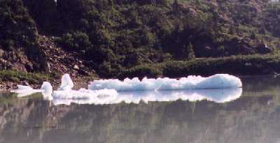
|
From Portage we just kept rolling north, right through Anchorage where we slowed only for traffic lights and on to the junction of Highway 1 with 3, the George Parks Highway, near Palmer. The scenery today was largely obscured by smoke from forest fires burning in the interior. There's a big high pressure system just west of us which is causing northerly winds to carry the smoke southward. That, plus the fact that much of the highway runs through the lowland valley of the Susitna with big birch and alder trees lining both sides of the road, made sightseeing today less than outstanding. Without the smoke we might have been able to see the big mountain; but, when we stopped at what was recommended as a "photo must stop", we could hardly make out the mountain range, let alone McKinley. Ah well, from the pictures we've seen that others have taken, McKinley isn't nearly as striking a mountain as many others. Unlike the volcano peaks we saw yesterday and those of Washington and Oregon, McKinley is just the highest of many peaks in the Alaskan Range. It doesn't stand alone. Even on our side trip to Talkeetna, the jumping off place for McKinley climbers, the view was almost completely obscured by the smoke. In Talkeetna the streets were jammed with people, doing what I can't imagine. Many backpackers, way too many to be prospective climbers, were sitting at roadside tables and benches. The airport was busy too. We saw several planes with skis, probably taking people to the glaciers. We opted to have lunch at a pleasant lodge just outside of town.
We got to Cantwell where we had planned on spending the night about 16:30 and spent a half hour looking over the available accommodations. Not all that great. We'd hoped to at least get an RV park with showers, but the one we looked over was crowded with vehicles parked in a big gravel lot only a few feet apart. The one motel on the highway was a grubby looking place and another which advertised log cabins for rent had only a community shower room. We'd given up and decided to camp out another night and had headed out the Denali Highway when we spotted a sign for the Backwoods Lodge. Well, why not? Yes, they had a room and not only that, it is beautiful! It's the nicest place we've stayed in a long time. The rooms are in a large log building, but are finished in a very up-to-date manner. Ours has two queen beds, good ones, a bunk bed, big spotless shower, frige and coffee maker, dishes in the cupboard, and a sink in which to wash them. Outside the front door on a nice porch is a gas barbecue and the owners have steaks for sale in the office. It's run by a couple who have lived here in Cantwell since 1970, before the Parks highway was constructed. Neat people, they seem to love doing what they do. They even provide a canoe for their guests to use on a small nearby pond.
|
Saturday, June 28,
1997
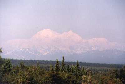
And what's more, the phone works! I got on line this morning, downloaded 34 messages and sent a trip report to family and friends. Neat! We hung around the motel this morning until 09:00. It sure did feel good to have a hot shower and put on clean clothes. The other plus for the morning was that the skies were clear and much of the smoke had dissipated leaving a reasonably clear view of Mount McKinley. From the hill above Cantwell it was big and white. I took a couple of pictures of it as we left, the brochures have lots better. |
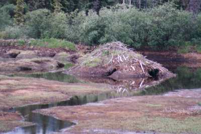
| Lois counted eight beaver houses in the Tangle Lakes area. One must have stood six feet out of the water. The beaver seem to prefer a small lake, maybe 50 yards in diameter, and all but one house was built out from shore. The houses are shaped like small haystacks averaging five feet high and maybe ten in diameter. Nothing but that pile of tangled sticks is visible above water. From what we've read, the insides are a mass of passageways and rooms, dry and cozy above the waterline. | 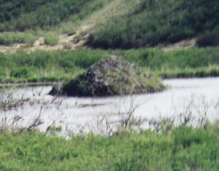
|
Sunday, June 29, 1997
Wow! We'd read the term but couldn't picture what the "top of the world highway" would be like. It's well named. But, I'm getting ahead of myself again. We woke to another bright, sunny morning after a quiet night by our singing stream. Only two other campers in the park and they were quiet types. Had breakfast and then, as planned, rolled on into Tok, on the way crossing over the divide between the Copper River and Tanana watersheds. The Copper flows to the Gulf of Alaska near Cordova while the Tanana flows into the Yukon and out to the Bering Sea. The headwaters of both are filled with little lakes and marshes, beautiful to drive through. In Tok we filled out water and fuel tanks, gave Henry a bit of a washdown, did a couple of loads of wash at the laundromat, bought a few groceries and a couple of bottles of vodka, cheaper here than in Washington, then headed for the junction at Tetlin.
After all the negative things we'd heard and read about the Tok to Dawson City road we were pleasantly surprised. The first twenty miles or so were not even gravel, they had been newly chip sealed with a fine red rock that made the surface considerably smoother than the cutoff road we were on yesterday. After that the road became gravel and somewhat dusty, but it was well graded. Good 40 mph highway. There was very little traffic going our way but we met quite a bunch of RVs going the other way. For the first hundred miles the road winds through river valleys filled with mining equipment and over spruce covered hills. Not especially scenic country. We stopped at Chicken, a tourist trap if I ever saw one, for lunch...two pieces of pie and one cup of coffee for $7.50. About forty miles farther is the junction of the road to Eagle, on the Yukon 65 miles to the north. We thought about it and decided to skip that side trip.
Then, just past Boundary, another group of shacks designed to separate the tourist from his money, the road starts to climb...and climb, and climb. The border is part way up the hill, just above the timber line. No problem there with customs. The nice young lady asked all the normal questions, I gave the prescribed answers, and on we went to the Top of the World.
|
What a drive! After reaching something over 4,000 feet the road rides the crest of ridges through tundra covered mountains from which you feel you can see forever. Although the scene isn't as majestic as that of the glacier covered peaks we've seen the past few days, this view outdoes anything for expansiveness! We found our home for the night right up there in a lupine filled field of tundra beside an outcropping of what Milepost calls Castle Rock. The lupine up here is something special too; it's a deep blue and seems to grow everywhere. What a neat place! |
What a night, or non-night that is! This would have been the place from which to watch the summer solstice. Even this evening, nine days later, the sun barely disappeared below the horizon about 01:30. We had our coffee, packed up, and headed down the last thirty miles to Dawson. The Top of the World Highway doesn't really start dropping until about ten miles from the river, but then it comes down in a hurry.
| The free ferry that takes you across the river to Dawson is interesting, and a bit exciting. Unlike every other ferry we've been on, this one has no permanent ramp or moorings. The skipper simply drives the boat up to the graded gravel bank, drops his ramp and holds it in place with the engines while loading and unloading. With the swift current of the Yukon River, that's a bit of a trick. The ferry ride is only about five minutes long, and our timing was perfect. The ferry was unloading as we drove up and we were the first car on. As we drove on the ramp was moving under our wheels. It seemed to work efficiently, though. As we drove off on the east bank big trucks and tour buses were lined up waiting to cross. | 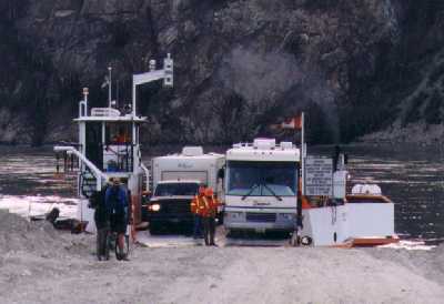
|
We had breakfast in Dawson at the Chinese Palace and took an early morning tour of the town. The streets of Dawson are still unpaved and many of the buildings look like they were built near the turn of the century. It's obviously slanted toward the tourist industry today, but it's not as 'cutsie' as many of the fake old western towns. The feeling of old west is real. You can almost see the gold seekers in the streets.
At a service station on the way out of town we put 60 pounds of air back in Henry's tires...amazing how much better ride you get on a rough road with 40 rather 60 psi in the tires...then headed south on Yukon 2. The morning drive wasn't much to talk about, mile after mile through tunnels of tall willow and birch which line the roadway, no humps or bumps and not many turns. Not until we got to Stewart Crossing did the scenery get better. From there on there were hills to climb and views of lakes and streams. The wild flowers are in full bloom now. The big burned area around Minto is alive with color from the Fireweed blooming on the floor of the charred forest. We stopped in Carmacks for a cup of soup at the Gold Panner Cafe and again at Lake Laberge to buy a "Monster Cinnamon Bun" from "Mom". Got to White Horse about 15:00, filled our tanks with gas at $1.89/gallon, bought a bucket of chicken at Kentucky Fried, got lost for a while until I realized that there's only one way in and out of White Horse, then rolled a few miles down the Alaska Highway to the Wolf Creek Campground, a bit crowded but nicely laid out to give maximum privacy for the sites. Nice evening in the trees with a creek flowing by.
| Tuesday, July 1, 1997
A very pretty and variable day today, some very good road, some not so good, some great scenery, some tunneling through the trees. I've certainly changed my picture of the "Alcan", which was based on bits of information picked up from people who traveled it years ago. The Alcan of today meets the standards of major secondaries anywhere, and there's no need to be concerned about sources of fuel or supplies. It did take us a bit of doing to find a place to buy milk today, several places were closed. We learned why when we finally found a small grocery store in Watson Lake open...today is Canada Day, a major Canadian holiday. We'd guessed it might be something like that when there were no road crews working along the highway. We bought our milk and fueled up (at $1.95/gal this time) in Watson Lake...not much of a town...then went back to the junction and turned south on the Cassiar Highway. There was considerable traffic on the road between White Horse and Watson Lake, most of it northbound RV's. But, once we turned south onto the Cassiar it was very light. We stopped early for the day at the very nice BC Provincial Park at Boya Lake. Our campsite is in the trees right on the water with a great view of the mountains across the lake. Tomorrow we'll head off into the Cassiar and Skeena Mountains to see some more glaciers. |
|
Several pluses and a big minus for this day. It started out as nice as yesterday ended, with a bright sun rising over the mountains to the east of Lake Boyo. A gentle breeze make the leaves of the aspen around us quiver in the morning sun. We ate breakfast on board, filled our water tank at the central well, a bit of a trick because you have to pump the water with a big hand pump. Fortunately, we had a plastic gallon jug out of which we cut the bottom. Lois got pretty good at filling it and carrying it over to the van where I could pour down the funnel to our tank.
There's not a whole lot to say about the Cassier Highway from Boyo Lake to the Meziadin Junction except that it is a very pretty drive over hills and through green river valleys. That's hardly enough for us these days. The good road surface disappeared a few miles south of Boyo. From then on it alternated between quite rough, beat up chip-seal, graded gravel, and asphalt. We stopped at Jade City, a rock shop just south of the company town of Cassiar at about eight o'clock. They didn't open until nine but I bought a nice piece of jade from them anyway. It was lying on a table with a $10.00 tag on it so I took it and left a bill under another rock.
A little farther along we were waved down by a guy at the side of the road. A motorcyclist, he had lost a tire and had been there since three in the morning. We normally don't pick up people but this guy was very well mannered, neatly dressed and well groomed with a jaunty Harley Davidson cap on his head. We gave him a ride for about thirty miles into the little community of Dease Lake where he could make a phone call for help. Kind of a crazy guy...he's from Southern California, forty-nine years old, and has the goal of riding to all the 50 states and all of Canada's provinces before he's fifty. He rides that bike 16-18 hours a day, stopping only to eat and sleep.
|
Soon after we dropped the biker...he never volunteered his name and I didn't ask...it started to rain, first we've had in over a week. It wasn't a hard rain but it was plenty to make mud on the gravel and dirt surfaces. Poor old Henry started getting a real mud bath. Then we stopped to take a picture of the biggest beaver house we've seen and Henry refused to start. Just a click when I turned the key to the start position. Okay. I crawled under the van with my chunk of jade, pounded on the starter, and had Lois try again. Harummm! He's running. There must be a bad segment in the armature, just hope it lasts until we get home. |
Well, what to do? We were 200 miles from the nearest place we could count on finding a garage. My check of the manual told me that there were two methods of sealing the rear end. In one design the bearing is lubricated by oil from the differential, in the other by packed wheel bearing grease. I decided to gamble and keep heading for Stewart. Not much of a decision really, the other option would have been to call a tow truck and even a phone is hard to find in this country. Not long after that our spirits were picked up when Lois spotted a bear on the bank just above the road, a nice big black just poking along on the graded, grass covered bank. She wouldn't stop to let me get a picture, though. Bummer!
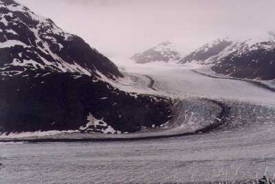
| Henry kept rolling along pretty much as normal except for that occasional clunking from the rear and, as we approached the junction with the road leading to Stewart, the scenery started getting better and better. Highway 37A to Stewart and Hyder turned out to be another of those unbelievably grand drives. Glaciers are everywhere! Spilling over granite cliffs thousands of feet above the canyon and, in one place, coming right down to road level as the Bear Glacier calves into a small lake in the canyon. I've been over-using the word "spectacular", but I don't know how else to describe it. | 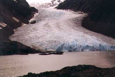
|
|
Rolling into Stewart a hefty vibration at 55 and 35 mph indicated that Henry's wheel bearing was going fast. We were lucky to have made it. Right at the intersection in the center of town I spotted a garage. It took only a couple of minutes for the mechanic to jack up the wheel and confirm that the bearing was gone...he could move the wheel up and down a half inch on the axle. "Have it in here at eight o'clock in the morning.", he said. "Okay, we'll be here." It was early and we found a room right down the street at the King Edward Motel. Very nice room with a full kitchenette and at half the price we were paying in Alaska. Stewart is a small town, about the size of Friday Harbor, in a cathedral like setting. A glacier hangs from a huge granite mountain just south of the city and waterfalls are everywhere you look. We didn't get a chance to do much driving around...I was afraid to overtax Henry. We'll do some more exploring when we get him fixed. |
Thursday, July 03, 1997
Lazy day in Stewart, BC. Managed to solve my e-mail problem, though. Lois had an AT&T card that had another 800 number on it that works here in BC. This morning I was able to download 9 messages and send family and friends an update to our trip log. Had breakfast at the hotel...not so very good eggs Benedict...then took Henry in to the garage. Bruce, the shop foreman, was very helpful. In a couple of hours he had everything done and Henry ready to go with one rather important exception -- the axle is ruined and, so far, he hasn't been able to find a replacement. We'll be around at least until tomorrow. Henry is movable, though, and Bruce found a place for us to park where we could get power and not have to shut down the frige.
| We spent the day exploring Stewart, not a big job even on foot. The town is only about six blocks long in either direction. Most of the businesses are on the street the hotel is on. Looking down any street your eye is drawn to the mountains, glaciers, and waterfalls at the end. We're in a deep canyon which doesn't stop at Stewart but continues for another 140 miles down a deep water inlet called the Portland Canal. Stewart advertises itself as "Canada's Most Northerly Ice Free Port". At the north end of town, by a lovely stream, the Lions Club has built a beautiful park, playground, and camping area. We walked down there today, visited the museum, and pretty much saw what there is to see here. Hopefully, Bruce will get Henry going again tomorrow and we'll be able to visit Hyder, Alaska on the 4th of July. | 
|
Well, our axle came in on this morning's bus all right, but it was the wrong one. Bob, the boss man at Granmac Services, spent another hour or so on the phone looking for the right one. About two o'clock Bruce called and said they thought they had one located which should be in Terrace, another little town about 200 miles away, in the morning. The bus between here and there doesn't run on weekends, but he thinks he's found a truck that is coming this way. He said to check about noon tomorrow. So, we're here for at least another day. We spent the day alternately lying around in the motel room and walking the streets of town. In the afternoon we moved Henry across the street just long enough to give him a bath. He sure looks better with the mud washed off. We missed the big 4th celebration in Hyder...I couldn't find a car for rent, a taxi, or a bus to take us there and I wasn't ready to commit myself to the two mile walk. Probably just as well, if we'd gone we'd have missed the more interesting celebration of the Mars landing and pictures. That was neat!
Saturday, July 05, 1997
Our luck seems to be holding, bad that is! The axle got as far as Terrace, at least that's what we were told, but the truck which was going to bring it on to Stewart canceled out its run and Bob wasn't able to find anybody else coming this way. Looks like we'll be here at least until Monday after the bus arrives. We spent another day poking around the motel and town. Strolled down to the park, eating an ice cream cone on the way, took a bunch of photos, talked to some people on the street. They are getting to know us now and always ask how Henry's doing. The folks in the motel have been very cooperative, even when we can't tell them how long we're going to stay. Our room is really nice with its full kitchenette. We've been eating most of our meals at home.
Being in Stewart is like being in Yosemite Park without the people and facilities. It's a tiny village in the bottom of a canyon surrounded by glacier covered, granite mountains towering 6,000 feet above the valley floor. Instead of the redwoods, giant spruce trees cover the lower slopes, clinging to the almost vertical walls. Waterfalls are everywhere you look. It's a spectacular place to be and, if it weren't so hard to get here, I'm sure would be overrun with tourists. They aren't here, though. You see a few RVs on the street and at the Visitor's Center, but it isn't a destination for big tour groups or cruise ships. The primary tourist attraction is the Salmon Glacier about 20 miles the other side of Hyder on the Alaska Side. We haven't seen that yet, but the big, blue glacier hanging right over town is no slouch. You can't walk to it, though, it calves a thousand feet up the wall of the canyon. I can only soak up so much scenery, though, before I'm ready to move on. Well, maybe tomorrow. Our axle should be on the bus from Terrace, which doesn't run on weekends, in the morning. If so we'll be on our way again.
Our long streak of good weather finally broke this afternoon. A front came through bringing lots of wind and rain and a couple of big booms of thunder. From what we heard on TV they had a real whing-dinger down south.
Sunday, July 06, 1997
And more rain today, not hard like last night, just a light drizzle for most of the day. I walked out to the airport in the morning. Not much there, no fuel, no FBO, a helicopter operation by Vancouver Island Helicopter with lots of Keep Out signs. Only one airplane on the ramp, a Piper Colt with a tent pitched beside it. Beautiful asphalt runway that doesn't look like it gets much use. I haven't seen a plane land or take off since we've been here. Wonder why? Not much else to say about the day, just another day of waiting. We'll sure be happy when we can get rolling again.
Monday, July 07, 1997
And we are, rolling and happy! Bob called a little after eight this morrning while Lois was across the street doing a final load of wash. Said our van would be ready in about an hour. Joy, joy! I picked ol' Henry up, after paying damages of $750 Canadian, we took about five minutes to load up, and we were back in the sightseeing mode. And nothing could have been better to put us back in that mode than going to see the Salmon Glacier. We now have a new Number 1 on our list of VSPs (Very Special Places) for this trip. We heard about, and seen pictures of, the Salmon Glacier...our book says it's the primary tourist attraction here...but nothing prepared us for the reality.
It's only two miles from Stewart to Hyder, a straight stretch of road along the north bank of the Portland Canal. You could see the Canadian Customs station at the edge of town from Stewart if the road didn't make a sharp bend to the right as it entered Hyder. Hyder is quite a contrast to Stewart. Instead of neatly laid out streets, curbs, sidewalks, and well kept buildings, Hyder is a collection of unpainted, sometimes falling down, shacks, many with signs advertising tax free goods and liquor. It's a little cleaner than most Indian villages, but not much neater. There is no U.S. Customs Station as you cross the border into town. The road sort of winds between the buildings and then heads off up a river valley with no signs telling you where it might lead. We followed what looked to be the most traveled route until the shacks disappeared and we were rolling along a gravel road beside a glacial river bed which we assumed might be that of the Salmon. About fifteen miles from town, just beyond a big mining operation, the road starts to climb and, coming over a ridge, we caught our first glimpse of the glacier. The next five miles were the grandest of our trip as far as scenery goes.
|
|
 We followed the road as far as a place where a rock slide had covered it, just
across from where the glacier makes a sweeping ninety degree turn to the north,
disappearing into the ice fields of the coastal range, stopping every quarter
of a mile or so to take a picture. Interestingly, we didn't see more than a dozen
cars all morning, one of them a bright yellow school bus loaded with tourists.
Why the place isn't swarming with sightseers, I can't imagine. We aren't complaining,
though, some of our favorite places are those which haven't been discovered by
the crowds. On the way back, at the mining operation, we saw a big wolverine making
his way across the flat below the road. That's the first time we've seen one of
those.
We followed the road as far as a place where a rock slide had covered it, just
across from where the glacier makes a sweeping ninety degree turn to the north,
disappearing into the ice fields of the coastal range, stopping every quarter
of a mile or so to take a picture. Interestingly, we didn't see more than a dozen
cars all morning, one of them a bright yellow school bus loaded with tourists.
Why the place isn't swarming with sightseers, I can't imagine. We aren't complaining,
though, some of our favorite places are those which haven't been discovered by
the crowds. On the way back, at the mining operation, we saw a big wolverine making
his way across the flat below the road. That's the first time we've seen one of
those.
The rest of the day went nicely too. We looked for a place to have lunch in Hyder, but the onnly restaurant was grubby looking, so we opted for the hotel in Stewart. Then it was back up the spectacular Bear River Valley with glaciers and waterfalls everywhere you look. At the junction with Highway 37 we turned south through mile after mile of second growth forest. Signs along the highway indicate that most of this area was logged in the 1970s and replanted as recently as 1989. Rolling around a curve we came on a Black bear strolling across the road. I slowed and grabbed the camera but about that time he must have heard us coming and finished his crossing at a gallop. No chance for a picture.
| At Kitwancool we took the old highway through that Indian village to see some of the finest totems we've ever seen, really nice carving, most of them unpainted. Turning east again at the junction with Highway 16, we rolled up the Skeena River toward Prince George. Found our home for the night at Seeley Lake Provincial Park, a lovely parking spot in the trees fifty feet above the lake shore. Ducks, geese, and dozens of small birds entertained us during our evening meal. Great to be back on the road again! | 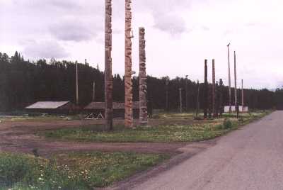
|
|
Tuesday, July 08, 1997
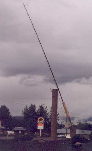
Nothing spectacular today, just a long, pretty drive over hill and dale. Central British Columbia is known for its agriculture and we saw a lot of it today. From Seeley Lake we followed 16 east through Hazelton, Smithers, and Houston, first along the Skeena River and then the Bulkley. Much of that country is devoted to tree farms, as was that we saw yesterday, but gradually more and more became open pasture land with scenes of cattle grazing peacefully on the hillsides. We are here at what must be one of the prettiest times of year. Everything is green and the roadsides are blazing with color. White daisies, yellow Canadian Butterweed, pink Fireweed, blue Lupine, and flaming red Indian Paintbrush are everywhere. In Houston we stopped to admire the "World's largest fly rod". a sixty foot long rod with a 21 inch long "Skykomish Sunrise" fly. Houston's 'thing' is fly fishing for Steelhead, claiming that sixty pounders are commonly taken from the Bulkley River which flows through town. |
Then, dropping down toward Prince George and starting to encounter tributaries to the Frazier, there is more pasture land and hay fields and big herds of dairy cattle. Love the odor of new mown hay and we got plenty of it today. The preferred method of bailing seems to be the big multi-ton rolls which, in several places, we saw encased in plastic. How they get it into the huge plastic tubes and how they handle it after that is a mystery to me. Prince George is a pretty city, as big cities go. You cross the wide Frazier River both going into and out of town. We didn't do much more than drive through the business area, fueling there for $0.159/liter, about $1.40 per gallon...prices for gasoline have been dropping steadily as we came east. Driving eastward from Prince George there is a definite decrease in population. Where to the west there are small towns and villages every few miles, to the east it is 97 miles to the first town, McBride, and instead of farms it is again the huge forest plantations. We stopped at McBride for a few groceries then drove on for another fifty miles to the Robson River Campground just beyond the junction with Highway 5. There is a startling change in scenery at that junction, suddently changing from gently flowing streams and softly contoured hillsides to white water rapids and craggy peaks. Our road map indicates that from here to Jasper and then down Highway 93 the drive is designated an "Official AAA Scenic Byway". We are looking forward to that tomorrow.
Wednesday, July 09, 1997
Well, we are happy to put our endorsment on the Triple A's designation of the route we took today as a "Scenic Byway". Never in our travels have we driven a route with more startling, stunning, and stupendous scenery. We started the day off right by encountering two young bull elk browsing just off the side of the road. The drive to Jasper was pretty as we climbed over the continental divide, the Alberta border, and the Jasper National Park boundry, all at the same place. A young lady at a toll station collected $8.00C from us as our daily fee for being in the park. Jasper is your typical SuperResort with hundreds of condos and other tourist accomodations` but it's clean and neat like most things Canadian. Interesting how many of the old residences have been spruced up and are advertised as "Tourist Accomodation"s, or B & Bs. The town was busy this morning, but not crowded.
Then it was south on the "Icefield Parkway" through the parks, first Jasper, then Bampf, and finally Kootenai. Except for the signs you can't really tell which you are in. They've done a great job on Highway 93. It is wide and smoothed surfaced with wide paved shoulders for cyclists. There are turnouts every few hundred yards to let visitors get off and take pictures without slowing the through traffic. I'd call the traffic today medium/light.
|
Although there were a lot of cars on the road, there seemed to be room for everybody without feeling crowded. The only place there were crowds was at the big lodges and visitor centers. There the parking lots were stuffed and people were swarming. At the largest, at the Columbia Glacier, there must have been two hundred tour buses lined up in the lot, plus a thousand cars. Needless to say, we stopped at none of these places, confining our viewing and picture taking to the roadside pullouts. |
| I took a lot of photos although, as with those I took in Alaska, there is really no way a picture can capture the feeling of being in those grand surroundings. In this section of the Canadian Rockies the spectacular landscape is based on the compression and uplifting of sedimentary rock rather than volcanic action. Millions of years of erosion has then carved fantastic shapes in the tortured contours of the squeezed earth crust. The glaciers topping this broken pile of old seabed provide a current illustration of how that erosion occurs. You can see where the ice, reaching a cliff over which it must fall, breaks off and melts carrying rock and debris into the valleys below. | 
|
Thursday, July 10, 1997
A pretty, but not outstanding, drive down the Columbia Valley and into Idaho today. Of course we've been a bit spoiled with our drives lately, we're getting pretty blasé about mere lovely hillsides and mountain streams. And, the country we traveled today is much more populated. We were almost never out of sight of someone's driveway. Got to the border about 09:30, ran on into Sandpoint where we had Henry lubed and his oil and filter changed at Wal-Mart. They had to add a pint of oil to the rear end; hopefully, Granmac didn't fill it quite to the top. Then it was on to the lake, stopping once more in Coeur d'Alene for a Wendy's Spicy Chicken sandwich. Sis and Paul were down at the dock riggiing the sailboat when we arrived, so we just moved in and made ourselves at home. Seems a little strange, and nice, to visit as a guest a place for which I had responsibility for so long. Had a nice afternoon visiting and trying to get Paul back on line with his notebook computer. He hasn't been able to sign on since he got here a week ago. No luck this PM, maybe in the morning.
I'll end this Alaska '97 log here. It's been a great trip. Since leaving Skagway we've put 5,596 miles on 'ol Henry over not always the best of roads, averaging 223 miles per day. He did pretty well in spite of his rear end troubles. He's also developed a click in the transmission which we need to check out before our next tour. Best wishes to all of you who have followed our progress and to those who plan to do the trip themselves in the future. We recommend it highly!
Dale & Lois Putnam